Hey, everyone. Gobblers by Masticadores has published another of my nature photography images titled “Craggy Rocks & Twin Lakes.” Sincere thanks to editor Manuela Timofte for her kindness in sharing this image with her readers.
You can view the image and its accompanying commentary here:
Just a quick note to say one of my nature photography images titled “Grand Tetons & Snake River at Sunrise” has been published at Gobblers by Masticadores. Editor Manuela Timofte does a wonderful job with her creative artists and I’m delighted to have my writing and photography hosted by her. Kindest thanks, Manuela.
You can view the image and its accompanying commentary here:
Peaks & Waterfall at Sunset, Glacier National Park, Montana (c) Mike Utley
Mount Oberlin and Cannon Mountain can be found along the Going-to-the-Sun Road which traverses Logan Pass in Glacier National Park, Montana. These two peaks cradle the remnants of an old glacier that feeds Bird Woman Falls, visible between the two peaks. In this 1996 image, I was on a very rushed one-day tour of the park with a friend when we spotted this sunset scene. I had no way to compose the image with a strong foreground object as I would have preferred as I was on the opposite side of the steep valley from the peaks, so I utilized the two trees seen here to act as a sort of framing device and to divide the image into thirds to create a more pleasing shot in my mind. The fact that one tree is dead and the other thriving was incidental to my decision to include them, but they do provide a contemplative aspect to the image, especially how the waterfall seems to feed the living tree on the right, while the dead tree on the left signifies day’s end as it contrasts with Mount Oberlin’s brightly gilded face bathed in the dying day’s last light. (Canon gear, Fuji Velvia ISO 50).
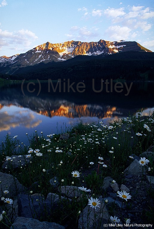
Sheep Mountain & Daisies, Trout Lake, SW Colorado (c) Mike Utley
I have a deep fondness for Trout Lake, located in southwest Colorado near the small tourist town of Telluride, about an hour from where I live. Early mornings and late evenings create some wonderful reflections of Sheep Mountain. I’ve photographed this location many times in all seasons. This image was made in the late ’90s during one fine summer evening when the sky was a gentle shade of pale blue and the daisies proliferated in abundance. I like the tranquility of this scene as the day’s last light illuminates the mountain, and delicate clouds whisper in the sky. I also like how the diagonal lines present in the foreground flowers act as a counterpoint to the horizontal line of the lake’s far shore. I’m reminded of early morning fishing as a kid—trout jumping after insects on the mirror-smooth surface–and years later, hiking among the trees with my camera as I sought to find peace and purpose in my world. It’s an idyllic place. (Canon gear, Fuji Velvia ISO 50)
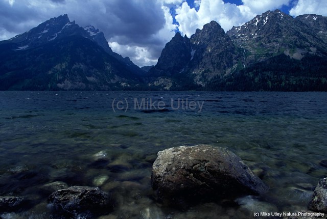
Tetons & Jenny Lake, Grand Teton National Park, Wyoming (c) Mike Utley
In this August 1996 image from my trip up north, I spent a couple of days in Grand Teton National Park in western Wyoming. This is a faerie-tale land of serrated peaks, forests, rivers, lakes and majestic wildlife. On this morning, after a rainy night, clouds obscured the peaks and hung low over the lakes and forest; a brooding presence. It was windy as I scaled the bank of Jenny Lake in order to set up my tripod in the water. I wanted a low angle for my 24mm lens to include the foreground rocks to contrast their smooth textures with the jagged Tetons in the distance. Small whitecaps adorned wavelets as the breeze came in off the lake and blew the clouds from the mountaintops. This is one of my favorite images. I like the raw power of the scene: the basic elements of earth, water and sky, as well as the turbulent motion of the water and clouds. The foreground rocks anchor the image and serve as a tranquil focal point / counterpoint to the chaos in the lake and clouds beyond. I also like the limited color palette here—it almost lends the scene the feeling of a black & white image and allows the viewer to focus more on the shapes and movement of the scene. (Canon gear, Fuji Velvia ISO 50)
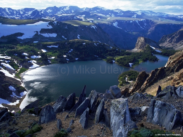
The Absaroka-Beartooth Wilderness is located in south-central Montana, with a small section overlapping into northern Wyoming. This area resides partly in the Gallatin, Custer and Shoshone National Forests. Named after the two predominant and geologically distinct mountain ranges in the area, this region hosts craggy peaks, conifer forests, glaciers and glaciated valleys, alpine tundra plateaus and deep canyons, along with many streams and more than one hundred lakes. The Absaroka Range is volcanic in origin and contains dark rugged peaks and more vegetation, while the Beartooth Range is mostly granite, with sweeping tundra and ground-hugging grasses, wild flowers and lichen.
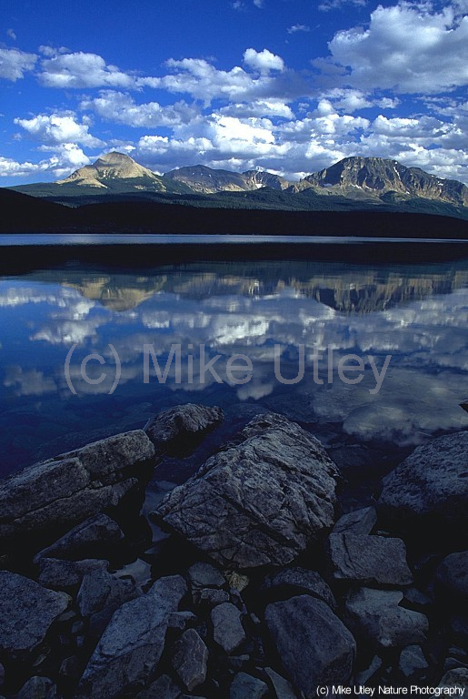
While driving through this area in August 1996, I was struck by the desolate landscape of the Beartooth Range, bereft of trees in many places, and the patches of snow which linger year-round. I was surprised to find many species of wild flowers that are present in the mountains of my area in southwest Colorado, only much smaller—under five inches in height–miniaturized due to the tundra conditions. This cluster of shark tooth-inspired rock slabs overlooking Twin Lakes in the canyon below caught my eye as an ideal foreground subject for a landscape image. The weather was spitting snow periodically, windy and chilly, and the lighting changed by the minute as thick clouds dragged their shadows across the tundra plateaus. This image isn’t perfect—the lighting was near-impossible to handle due to the brightly lit sky in the distance and rapidly shifting shadowed areas in the scene, hence the inclusion of only a sliver of the sky in this shot. Using a graduated neutral-density filter to attempt to hold back exposure in the sky would have proven futile in this instance—its use would have been painfully obvious, and in nature photography, a natural appearance is of utmost importance. Transparency (slide) film has such a narrow exposure latitude as it is, so I was surprised to end up with a decent image that captured detail throughout in both brightly illuminated and shadowed areas. I like the overall gloomy look of the image, as if portending doom (or just a snowstorm), and I think the jagged rocks in the foreground add so much texture and foreboding personality to the scene. Once again, my beloved 24mm f/2.8 wide-angle lens captured the image I had in my mind, and I was satisfied with the end result of this strange, desolate landscape. (Canon gear, Fuji Velvia ISO 50)
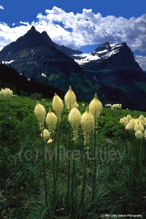
Bear Grass & Peaks, Glacier National Park, Montana (c) Mike Utley
While traveling through Glacier National Park in 1996 along the Going-to-the-Sun Road, this meadow came into view. I’d never seen bear grass before and had no idea what this unusual flower was at the time. The conditions were a bit tricky: contrasting lighting, a bit of a breeze, a slanting hillside, long-stemmed flowers and very slow slide film. In order to record this image, I had to make some choices.
First, due to the breeze, I needed a faster shutter speed than I’d usually use for such a shot with my 24mm f/2.8 wide-angle lens (which I typically closed down to f/22 for such images in order to achieve the most depth-of-field possible). This meant opening up the lens aperture a bit to allow more light to hit the film, which in turn meant a more shallow depth-of-field. Thus, I had to let the distant peaks go slightly out-of-focus and zero in on the bear grass, which was fine since that was the purpose of image anyway, and it caused the flowers to stand out more against the background. Depth-of-field (the amount of a scene—near to far—that’s in sharp focus) is inversely proportional to shutter speed at any given exposure setting: the more DOF, the slower the shutter speed, and vice versa
Second, the contrast between the subdued lighting in the meadow and the brightly lit clouds and peaks required the use of a two-stop soft-edged graduated neutral density filter in order to hold back exposure on the brightly lit sections and allow for a more balanced exposure overall. This slowed the shutter speed even more.
Third, the breeze had these flowers moving constantly and it was a struggle to wait for a lull during which I could expose a frame. Patience is crucial in nature photography since so little is under the photographer’s control—he’s at the mercy of the environment and must wait for the proper conditions to manifest before pressing the shutter button.
Fourth, I had to hold the rectangular graduated neutral density filter in front of the lens by hand since the filter mount was not made for wide-angle lenses and would end up darkening the corners of the frame (vignetting). This was more than a bit awkward and can be hit-and-miss and require several exposed frames to get one that works.
And fifth, all landscape photography requires a level horizon for proper orientation and a natural appearance. When shooting an ocean sunset, for example, it’s easy to use the horizon line as a level since all water lies horizontally. Or, if shooting a copse of trees, the vertical tree trunks can be a level indicator. But sometimes scenes have no obvious level indicator and can confuse the viewer. The slight slope of the meadow caused a problem here, and the solution was to make sure the vertical stems of the bear grass were clearly visible to act as an indicator of a level shot. Better quality tripods have built-in levels, but mine lacked this feature and I had to use environmental objects to imply a sense of proper level orientation.
After all of this, it was a matter of waiting for the breeze to die down enough to fire off a shot. And finally, once the slides were developed I checked my wild flower guidebooks to identify the bear grass. All in all, it took about twenty to thirty minutes to make this image, but it was time well spent. (Canon gear, Fuji Velvia ISO 50)
Mountain Reflections at Saint Mary Lake, Glacier National Park, Montana (c) Mike Utley
In August 1996, I made a trip to Montana to see my buddy Jeff. While I was there, we visited Glacier National Park, a sprawling piece of heaven along the northern border of the state. We didn’t have much time—only one day to spend in the park—so making images was a challenge as I was at the mercy of the clock. In the late afternoon of this day, we drove past Saint Mary Lake and, upon seeing the spectacular reflections of the clouds and peaks on the water’s surface, we stopped for a few minutes and I ran across the road and set up my tripod. I wanted to capture the mountain and cloud reflections along with the shaded rocks in the immediate foreground, so my trusty 24mm f/2.8 wide-angle lens was used. The lake was nearly mirror-smooth, and the clouds were sublime. I like the understated personality of the foreground rocks and the overall blue tones of the image. Glacier National Park can’t be experienced properly in one day—indeed, it would take a lifetime to explore—but I did the best with what I was given and I have some good memories of the day. (Canon gear, Fuji Velvia ISO 50)
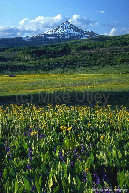
Lone Cone & Wild Flowers, near Groundhog Reservoir, SW Colorado (c) Mike Utley
The Lone Cone is a local icon in southwest Colorado. Located in the San Miguel Mountains about 24 miles from the town of Telluride, its 12,618-foot cone can bee seen from many miles in all directions. It resembles a pyramid on the horizon, and was clearly visible from the farm on which I was raised in southeast Utah. It’s a favorite local attraction of mine and I have several images of this peak. This particular image was made just beyond Groundhog Reservoir, about an hour and a half from where I live. It was early summer of 1995 and the wild flowers (mule’s ears, monkshood and lupine in this case) were just beginning to proliferate in the mountains. This vast meadow leading to the Lone Cone was awash in yellow and purple, and the late-afternoon sun warmed the flowers and the peak while a host of perfect summer clouds caressed the the sky.
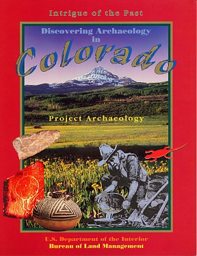
This image was selected by the Bureau of Land Management’s Anasazi Heritage Center near Dolores, Colorado for the cover of an archaeology textbook and accompanying CD in the late-1990s. Art Director Wayne Rice used the image as a background and layered several graphic elements on top. The original cloudy sky was removed and replaced with a gradient fill to allow the text to stand out more effectively. I was given proper credit for the use of my photograph on the credits page inside the book.
Textbook Cover–Wayne Rice, BLM
In 2001, this same image was again chosen by the BLM’s Anasazi Heritage Center for a poster commemorating National Archaeology and Historic Preservation Month in May of that year. Once again, Art Director Wayne Rice replaced the sky with a gradient fill and added graphic elements to the image to convey some of the historic aspects of Colorado’s past. A total of 7,000 posters were printed for this project and distributed throughout Colorado. After the release of the posters, I was told that Gale Norton, then-U.S. Secretary of the Interior, had one of the posters on display in her office in Washington D.C. What a thrill this was for me! It’s next to impossible to see, but the last two lines in the credits at the bottom of the poster list my name as the photographer. As a perk for contributing to the project, I received five copies of the poster.
Poster–Wayne Rice, BLM
It was a pleasant experience to work with Wayne Rice at the Anasazi Heritage Center on these two projects, and I was honored to be recognized in the credits of both projects as the creator of the image. Seeing up-close the process of a single image making its way into a finished product was intriguing and satisfying. (Canon gear, Fuji Velvia ISO 50)
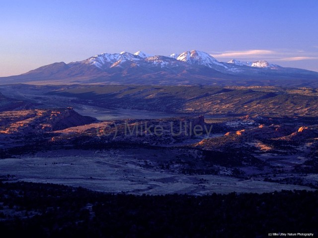
La Sal Mountains & Lisbon Valley, SE Utah (c) Mike Utley
Lisbon Valley is located in southeastern Utah and lies a few miles north of the farm on which I was raised. It’s a dynamic landscape of red rock desert and snow-capped mountains that rise incongruously out of nowhere. It’s a place of canyons and sandstone formations, sage brush and rabbit brush, cactus, cheat grass and fox tails, pinyon and juniper trees, as well as coyotes, foxes, mountain lions, jackrabbits and cottontails, mule deer, antelope and elk, hawks, rattlesnakes and other typical desert-dwelling fauna. I photographed this scene from a ridge where the landscape drops off into the desert valley below. Upheaval thrusts are visible, and the La Sal Mountains cling to spring’s last remnants of snow. This image was made in April of 1996 on a bitterly cold late afternoon, where the chill made for numb fingers and frosty exhalations. Metal tripods act as heat sinks during cold weather and freeze hands and fingers. Still, I’m fond of this image as it represents the varied landscape where I was raised. I’ve explored Lisbon Valley numerous times and felt at peace in the vast silence, surrounded by the scents of desert vegetation, warm breezes and clean air, as well as the stark, harsh environment of rock and sand and life that struggles to persist. Lisbon Valley is also home to a large open-pit copper mine (not visible in this image, fortunately) that is extremely unsightly and environmentally hazardous. Local ranchers are rightfully concerned about the high likelihood of contaminated groundwater, but corporate profits are all that seem to matter. Aquifers, habitats, wildlife and natural beauty are no match for some faceless company’s bottom line. (Canon gear, Fuji Velvia ISO 50)